On Friday afternoon, the NOAA Space Weather Center forecasted a great aurora for the Northwest and it happened. A tremendous event to watch. At the same time, the Center predicted a substantial event for Saturday night, but it never happened.
Aurora forecasts a day or two ahead often fail, while weather predictions are generally nearly perfect a few days into the future.
Why the difference between weather and auroral prediction?
To understand the auroral forecast problem, you must understand why auroras occur.
Auroras generally start with a disturbance on the surface of the sun, such as a solar flare or a coronal mass ejection (CME)---see below. Note that the corona is the outermost layer of the sun.
Courtesy of NASA
These disturbances eject vast quantities of charged particles that move at vast speeds (such as a million miles per hour!) away from the sun. Such ejections of charged particles can also alter the magnetic field around the sun. I should note that even without disturbances on the sun this is a background amount of particles leaving the sun, known as the solar wind.
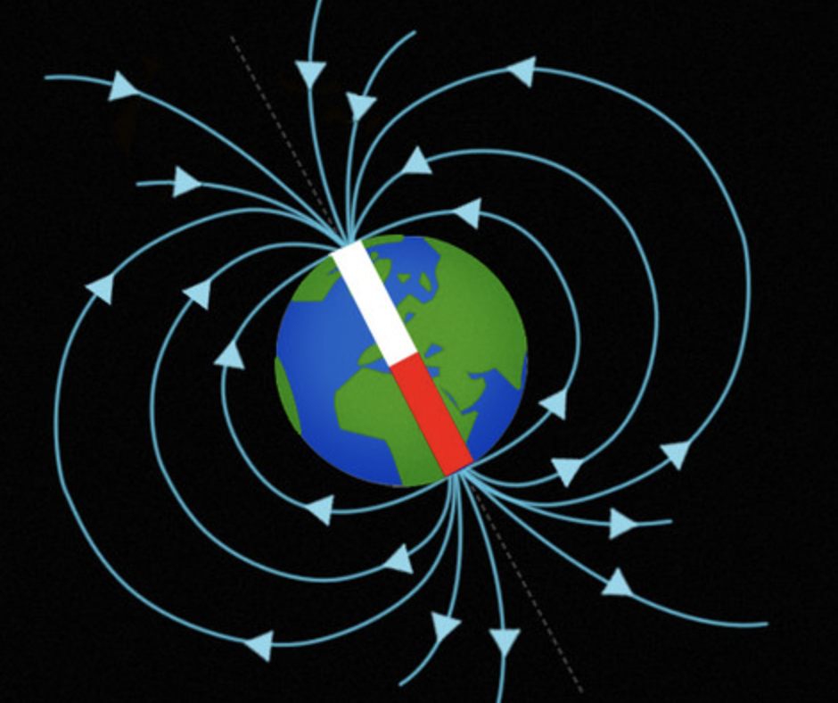
The sun has a magnetic field around it, and so does the Earth (see below, from Zappys). Note how the magnetic field lines (light blue) approach and leave the polar regions.
Now the key part. As particles from the sun (the solar wind) approach the earth, they interact with the earth's magnetic field, so that solar particles can enter the earth's atmosphere near the poles...or actually a ring around the poles centered on the earth's magnetic poles (see below).
These solar particles can interact with various atoms/molecules in the atmosphere (like oxygen and nitrogen), causing them to glow (just like a neon light tube). This is what causes the auroral colors.
During a solar storm, increased numbers of particles leave the sun, which can reach the Earth a day or two later. This revs up the aurora. It also disturbs the earth's magnetic field.
The aurora prediction problem
Astronomers have little skill in predicting disturbances on the sun's surface. Yes, we know that solar flares, sunspots, and CMEs are more frequent during the height of the 11-year sunspot cycle, but skill in predicting individual events--the ones that revved up the aurora on Friday-- is minimal at best.
But it is worse than that. The speed and direction of the particle ejection vary by event and it is very difficult to observe such parameters from Earth.
Like predicting where a ball will go, not knowing its exact speed and direction.
But there is some useful information at very short time ranges. NASA and others have spacecraft between the Earth and the sun at what is known as the L1 point, about a million miles towards the sun (see below).
Such spacecraft can sense solar particles approaching the Earth and provide reliable observations of changes 30 minutes to an hour before they reach the Earth, providing highly accurate auroral prediction. On Saturday afternoon, an L1 satellite gave the warming before the approaching solar particles and the incipient aurora. When I saw that data, I called my friends for an aurora party.
Right now, the NOAA Space Weather Center has noted another CME on the sun's surface and predicts the potential for a minor aurora tomorrow night (see below). So I will be watching the L1 satellite data, just in case the forecasts are wrong again.


